Nikolaj Jesper Cyon https://www.cyon.se/
Swedish visual artist
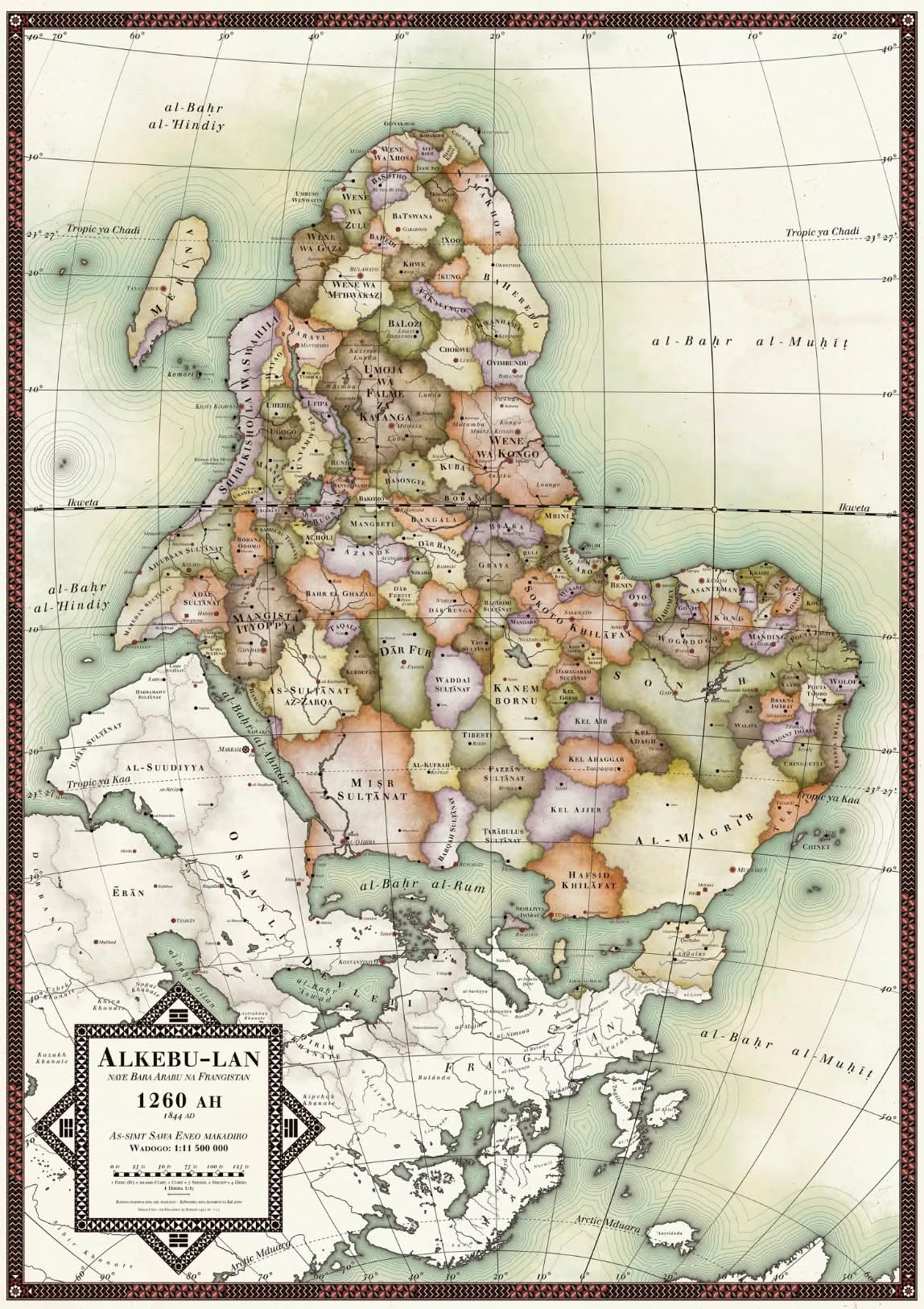
Alkebu-lan 1260 AH
All posters are sold out, but get notified then the new map is ready and
you will receive a email then it is with a discount code as well here:
here! https://www.cyon.se/store
Work is under way for a new map
Watch a Prezi presentation of the background here
http://prezi.com/zqjrcx-uj7d_/?utm_campaign=share&utm_medium=copy.
See a high resolution image (but with watermarks) here
https://www.cyon.se/s/Alkebu-lan-1260-AH-medium-resolution-fair-use-with-watermarks.jpg
The map is a map of an Africa that was or chere https://www.cyon.se/storeould
have been if history would have played out a bit differently. It took
almost a year of artistic research and crafting to make this map and even
if I am not a professional historian I would dare to claim that is a
fairly accurate representation of the most prominent states and cultural
groups in pre-colonial Africa though at times quite an anachronistic model
I have first and foremost looked at historical states ie territories with a
centralised government during the point they controlled the largest areas
during the time frame of 1300 - 1844 AD with most of the states in the more
recent part of that time frame. In areas where no centralised government
existed that I could find information about I have looked at names of
cultures that have inhabited an area for a longer time and where there is
at least some information. As a last resort, I have used the names of the
language groups that existed in the area.
When it comes to other specifics of the map here are some details: The map
is ‘upside down’ compared to the common practice today where North is
considered up, but in old Islamic cartography South was often on top, and
the context of Sankoré Madrasah – a medieval Islamic university with 25 000
students in the city of Timbuktu in the 14th century Mali Empire is the
normative setting of the map.
Therefore Timbuktu is chosen on the map as the place where the zero
meridian goes through instead of Greenwich in London. Therefore is also the
date 1260 AH (Anno Hegirae, years since the Hijra of Muhammad in 622 AD)
Islamic, and Alkebu-lan was old Arabic for ‘Land of the Blacks’. The names
of ‘tribes’ in Europe or as it was known in the Islamic world ‘Frangistan’
as well as the names of the ocean is all spelt in Arabic transcribed with
Latin letters.The font used for all text on the map is ‘Justus’ because it
closely resembles the fonts used for old 19th-century maps.
The map uses a ‘Lambert azimuthal equal-area projection’ which display the
size correlations between Europe and Africa much better than the often used
‘Mercator projection’ which make you believe that the continents are
roughly the same size. Africa is more than three times bigger. Madagascar
is, for example, bigger than Sweden and Denmark (not counting Greenland)
together.
The map legend - shaped like an eight-pointed star, uses the original
Chinese symbols for the points of the compass, the text is written in. I
hope is not a poor online translation of Swahili. It indicates, among other
things, that ‘the map is written in Swahili with Latin letters for the
educational purpose of our European subjects’.
[image: Work is in progress for a new edition of the map.]
Work is in progress for a new edition of the map.
The new map will have 2-5 times as many nations and 10x towns. It will have
a much more African style aesthetics with large graphic patterns and
natural features such as deserts, jungles and mountains.
This image is a work in progress; the nations’ colours will have a
beautiful watercolour look and all text printed.
I prioritise historical accuracy and will try to show even more diversity
instead of maximising big empires as the original does.
I work on the map more than 20 hours a week and hope to have it ready for
sale in the spring/early summer of 2023.
[image: Horn of Africa]
Horn of Africa
I made the image 15% larger by zooming in, some special solutions are
required to fit everything, like the amazing island of Socotra.
[image: “Frangistan” AKA Europe]
“Frangistan” AKA Europe
I want have any borders here so the patterns can shine on their own. There
is also mountains but that layer is not visible in this pic.
[image: Marocco/Al-Andalus (Spain)]
Marocco/Al-Andalus (Spain)
Here the mountains are clearly visable and also salt pan patterns.
[image: Alkebu-lan 1260 AH smart low.jpg]
[image: Alkebulan print I detalj 2.jpg]
[image: Alkebulan print I detalj wrinkeled.jpg]
[image: Alkebulan print I detalj.jpg]
[image: Alkebulan print II.jpg]
[image: Alkebu-lan comparsion a.jpg]
[image: Alkebu-lan comparsion biomes.jpg]
[image: Alkebu-lan comparsion etno lingvistik 1.jpg]
[image: Alkebu-lan comparsion etno lingvistik 2.jpg]
[image: Alkebu-lan comparsion modern map.jpg]
[image: Alkebu-lan comparsion mountains.jpg]
prev / next
Back to Work
[image: Closeup.jpg]
Iwo-oorun Alkebu-lan 1270 AH
https://www.cyon.se/iwooorun-alkebulan-1270-ah/
[image: Alkebulan print I detalj.jpg]
Alkebu-lan 1260 AH
https://www.cyon.se/alkebulan-1260-ah/
[image: uppslag 5.jpg]
Vyssan lull - Lyssna
[image: Detail -Territorial Control -Hughes Reef.jpg]
Territorial Control
https://www.cyon.se/terretorial-control/
[image: Erdanteil_12_2560px.jpg]
Dein Erdanteil
https://www.cyon.se/dein-erdanteil/
[image: kamera maj - juni 2014 071 - redigerad.jpg]
Facilitator of Social Bonds, Unit of account, Medium of exchange and Store
of value.
https://www.cyon.se/new-gallery/
[image: okinotorishima - aerial - whole.jpg]
Okinotorishima
https://www.cyon.se/okinotorishima/
Dido Problem
https://www.cyon.se/dido-problem/
Public Projects
https://www.cyon.se/public-projects/
Powered by Squarespace http://www.squarespace.com/